
A summary of the Library of Congress's American Revolution map resources (part of the 250th celebration)
I attended a virtual session yesterday (a PD session I also promoted here on ECONandMore for June) from the Library of Congress promoting their Revolutionary War map materials for the 250th anniversary of the United States, as well as a new collaboration between the LOC Geography and Map department and the National Library Service for the Blind and Disabled. Some quick links to map resources at the LOC are provided below, along with a few other LOC links on the Revolutionary War Era.
As usual, I'm just providing a sampling of the primary content - use the links to access the actual primary sources and teacher guide. I have also included here repeats from some of my previous LOC posts (like access to primary source review worksheets for students), as well as two areas prompted by Q&A responses in the second half of the presentation . . .
General information on the LOC's Geography and Maps Division:
About the Geography and Maps Reading Room - https://www.loc.gov/research-centers/geography-and-map/about-this-research-center/
Featured Collections of Maps (for the most popular topics) - https://www.loc.gov/research-centers/geography-and-map/about-this-research-center/
"Worlds Revealed" blog articles for the Geography and Maps Division - https://blogs.loc.gov/maps/
LOCMAPS Twitter/X Account - https://x.com/LOCMaps
"Ask a Librarian" - Research assistance (in this case specific to the Geography/Maps collection) - https://ask.loc.gov/map-geography/
Library of Congress Teachers Guides - https://www.loc.gov/programs/teachers/getting-started-with-primary-sources/guides/ Two specific PDF tools to keep in mind:
LOC's Primary Source Analysis tool - https://www.loc.gov/static/programs/teachers/getting-started-with-primary-sources/documents/Primary_Source_Analysis_Tool_LOC.pdf
LOC's Teachers Guide to Analyzing Maps - https://www.loc.gov/static/programs/teachers/getting-started-with-primary-sources/documents/Analyzing_Maps.pdf
Specific resources/maps mentioned in today's presentation (at least ones I found potentially interesting for K-12 teachers):
Virtual Orientation: Mapping America’s 250th Anniversary with Graphics
This blog post from the start of this month provides an introduction to the collection of resources that were featured, including links to the primary source documents - https://blogs.loc.gov/maps/2026/06/mapping-americas-250th-with-graphics/
American Revolution and Founding Washington
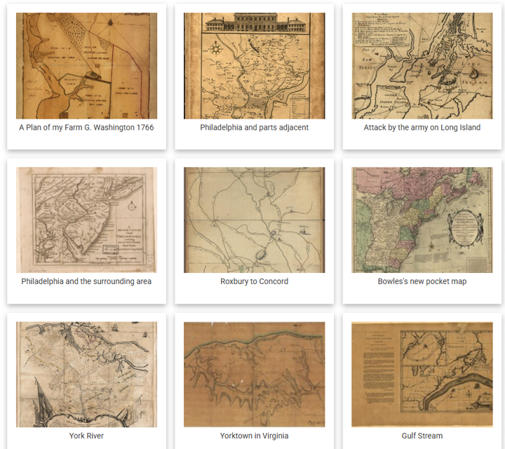
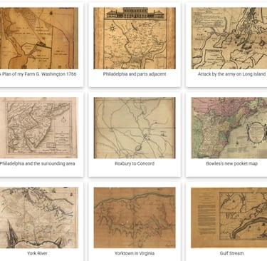
This is a specific collection created for the 250th Anniversary, featuring maps from the founding period (and then linking to items from the larger collection). Below I will feature a couple of the maps shared in yesterday's session - https://www.loc.gov/free-to-use/american-revolution/
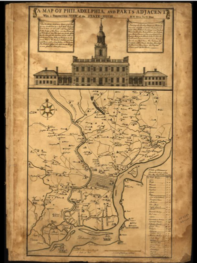
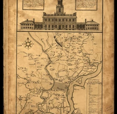
This is a map of Philadelphia from 1752, showing the surrounding
area and featuring a drawing of the "new" state house at the top.
One thing I learned in the session is that the drawing was speculative
since the building wasn't finished (so the design of the bell tower was
not public knowledge - the map maker must have received access to
the architect's plans). This, of course, is the building that we today
refer to as "Independence Hall".
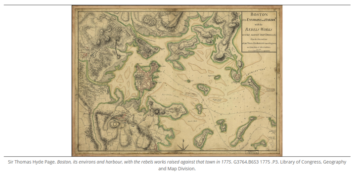
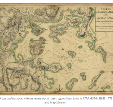
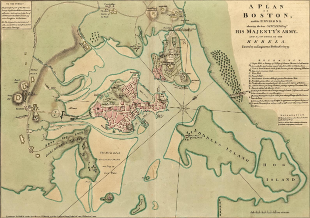
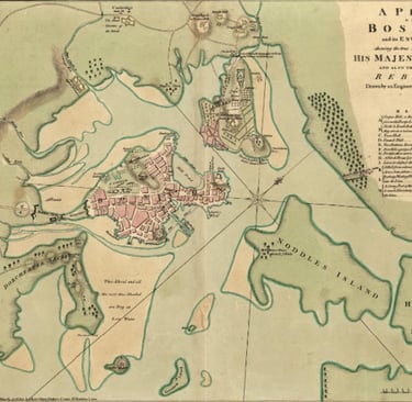
Above is a map from the British perspective of the siege of Boston in early 1776 (after the Battle of Bunker Hill, but before the evacuation of Boston later that spring).
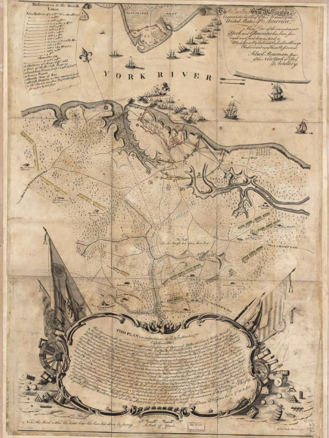
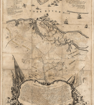
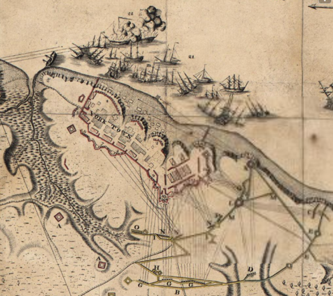
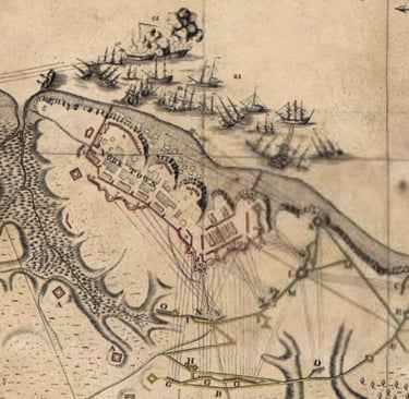
The Rochambeau Map Collection
If you are not familiar with the Comte de Rochambeau, he was the overall commander of French land forces in North America during the French alliance with the American colonies after 1778. Some of the maps in this collection were ones he was given to familiarize him with regions of the colonies (for example, the French were based for training in Rhode Island during long stretches of 1779 and 1780 while the war was transitioning to the South). Others, like the map I feature below, were created during the Yorktown campaign to identify British, French, and American positions. The map on the left is the "big picture" - then I magnified a section and screenshotted it on the right showing the British positions and outer redoubts to demonstrate how this might be used to plan attacks on General Cornwallis's forces. - https://www.loc.gov/collections/rochambeau-maps/about-this-collection/
In addition to the focus on America 250, the LOC session touched on two other pieces I want to mention here.
First, the second half of the presentation talked about the resources the Library of Congress has to assist vision-impaired patrons, specifically in this case with Maps and Geographic resources (which many people think are only visual format). I'm going to give (below) a couple of examples and links if you want to learn more.
Second, the Q&A portions always bring up some great questions about specific resources, and this session was no different. So I grabbed a couple of the map resources asked about to include here . . .
America250: NLS Celebrates America’s 250 Years
The National Library Service (NLS) for the Blind and Print Disabled at the Library of Congress makes a lot of resources available at this webpage - https://www.loc.gov/nls/ But for this session they primarily focused on resources connected to "America 250", and particularly map/geography resources - https://www.loc.gov/nls/services-and-resources/america250/.
As they explain on that page, "In particular, NLS has started work on a collection of accessible maps and documents that provide a representative record for the semiquincentennial – items that will be available on this page as downloadable audio, braille and tactile materials. These materials will preserve digital content reflecting commemorations, historical interpretation and community experiences. Tactile maps use raised surfaces or braille dots that allow a visually impaired person to interpret." A couple of examples are given below:
Q&A Features - "Washington as Public Land Surveyor" and "Native American Spaces: Cartographic Resources at the LOC"
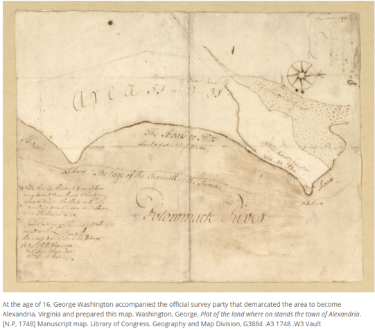
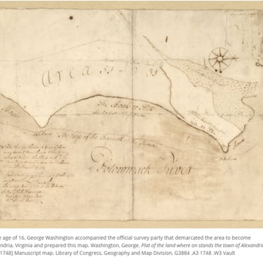
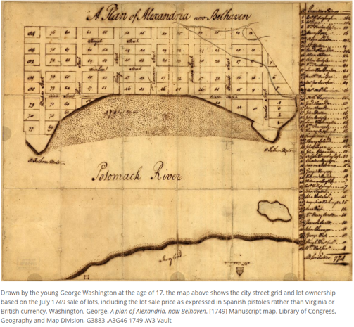
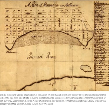
As I mentioned above, the Q&A portion during the second half of LOC sessions tend to be very wide-ranging - some of the questions get very personal or focused on individual research needs, but most of the questions tend to be interesting "rabbit holes" related to the main topic. In this particular case, I found two topics interesting enough to post here. The first one was a question related to the use of maps by General George Washington during the Revolutionary War - the teacher asked if Washington's previous experience as a surveyor had impacted his interest in accurate maps during the war. In response, the LOC staff linked participants to a webpage about Washington's experience using primary sources from the period - https://www.loc.gov/collections/george-washington-papers/articles-and-essays/george-washington-survey-and-mapmaker/washington-as-public-land-surveyor/
If you are interested in learning more about the process of 18th century surveying (as opposed to the results) you could also take a look at this article on "Surveying: The Art of Measuring Land, Part One" - https://blogs.loc.gov/maps/2019/11/surveying-the-art-of-measuring-land-part-one/
The second one was a question asking about the availability of maps created by Native Americans during that same timeframe (the Revolutionary War period) in the Library of Congress system. In response, the LOC staff linked participants to a webpage about Washington's experience using primary sources from the period - https://www.loc.gov/collections/george-washington-papers/articles-and-essays/george-washington-survey-and-mapmaker/washington-as-public-land-surveyor/
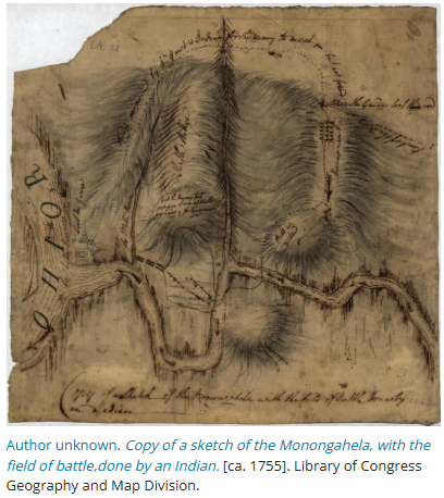
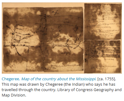
As they explain on that page, "Maps drawn by Indians, as well as evidence of their contributions to European-created maps, are valuable and rare documents for studying Indian peoples' geographical knowledge and spatial understanding. They complement the oral record, and they also help establish and clarify the Indians' role as guides and informants in furthering European explorations in North America. The Geography and Map Division does not have original examples of Native American cartography that pre-date European contact, but it has two eighteenth-century manuscripts created by Indians for use by Europeans and a few reproductions and facsimiles of other maps drawn by Indians." A couple of examples are given below:
ECON and More
Curating articles for K-12 education.
CONTACT
© 2025. All rights reserved.