The Library of Congress's Geography and Map Division
Earlier today, I attended a virtual orientation on the Library of Congress's Map and Geography Collections. It was actually two-fold - 1) an overview of their collections; and 2) an overview of the LOC's new search engine (which just starting being used last month). I'll also add a few other links to historic map resources.
Jay LeBlanc
8/12/20253 min read
As I noted above, these resources are coming out of a virtual orientation I did earlier today with the Library of Congress's Map and Geography collection (though several are ones I have used in the past). I attended 2-3 similar orientations from other LOC collections over the summer - some of those I will probably post about during "slow news days" later in the semester. Unfortunately the LOC tends to schedule these sessions in the middle of the work day - great for full-time researchers and college professors (who often have a lot of schedule flexibility) but not so good for classroom teachers. But now I can give you the Cliff Notes version!
Just as a reminder, I already have links to basic information about the Library of Congress in the History, Civics, and Geography Resources page (accessible in the pull-down menu of Resource Pages above, OR click on this underlined sentence). So for this blog post, I'm going to focus specifically on the Maps and Geography collection, with links to new material and specific links brought up during the Q&A portion (which I always enjoy - people bring up ideas I would never have thought of).
General information on the LOC's Geography and Maps Division:
About the Geography and Maps Reading Room - https://www.loc.gov/research-centers/geography-and-map/about-this-research-center/
Featured Collections of Maps (for the most popular topics) - https://www.loc.gov/research-centers/geography-and-map/about-this-research-center/
"Worlds Revealed" blog articles for the Geography and Maps Division - https://blogs.loc.gov/maps/
LOCMAPS Twitter/X Account - https://x.com/LOCMaps
"Ask a Librarian" - Research assistance (in this case specific to the Geography/Maps collection) - https://ask.loc.gov/map-geography/
Library of Congress Teachers Guides - https://www.loc.gov/programs/teachers/getting-started-with-primary-sources/guides/ Two specific PDF tools to keep in mind:
LOC's Primary Source Analysis tool - https://www.loc.gov/static/programs/teachers/getting-started-with-primary-sources/documents/Primary_Source_Analysis_Tool_LOC.pdf
LOC's Teachers Guide to Analyzing Maps - https://www.loc.gov/static/programs/teachers/getting-started-with-primary-sources/documents/Analyzing_Maps.pdf
Specific resources/maps mentioned in today's presentation (at least ones I found potentially interesting for K-12 teachers):
Native American Spaces: Cartographic Resources at the Library of Congress. Here is an introduction to this collection, with 500 years worth of maps - https://guides.loc.gov/native-american-spaces And here is a page of featured maps that might connect to a specific time period or event in your curriculum - https://guides.loc.gov/native-american-spaces/featured-maps
NOTE - As a follow-up to the previous topic, someone in the session asked about maps of treaties with native Americans. The LOC has a small collection - https://guides.loc.gov/native-american-spaces/cartographic-resources/treaties - but most (as official government records) would be held by the National Archives - https://www.archives.gov/research/native-americans/treaties
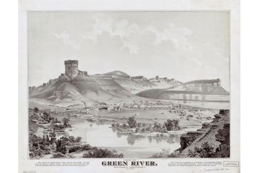
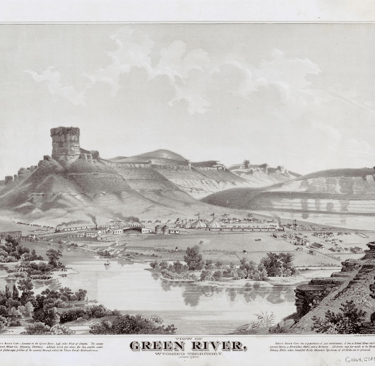
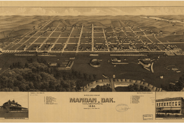
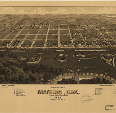
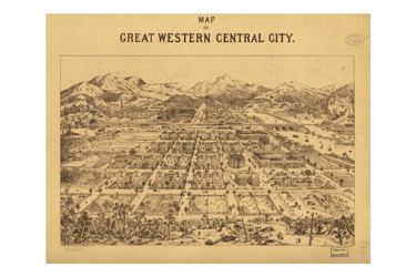
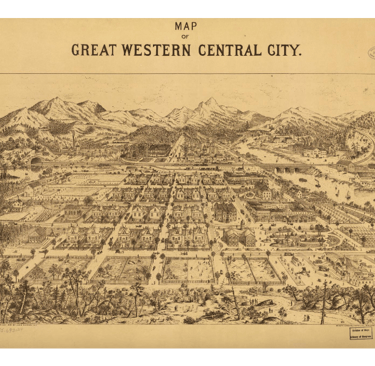
View From Above: Exploring the Panoramic Map Collection. Here is a U.S. map showing locations of the 1,726 panoramic maps in the LOC collection - https://www.loc.gov/collections/panoramic-maps/about-this-collection How about examples from our area of the U.S.? (From L to R, Green River WY, Mandan ND, and Central City CO):
Civil War Maps - https://www.loc.gov/collections/civil-war-maps/about-this-collection
Exploration Maps (in English, Spanish, or French depending on the explorer) - https://www.loc.gov/collections/discovery-and-exploration/
Sanborn Maps. The most-used part of their collection (according to the librarians) - these are fire insurance maps of many major cities over the past 150 years, showing how cities developed. Those risk-assessment maps, of course, are also the starting point for the issues of "redlining" in the 1930s and 1940s (a WHOLE different subject for a different post!). https://www.loc.gov/collections/sanborn-maps/about-this-collection/
One more interesting one from the Q&A session - someone asked about maps from Pierre Charles L'Enfant from his development of the city plan for Washington, D.C. They pointed us to 2 blog articles - https://blogs.loc.gov/loc/2025/08/lenfants-d-c-blueprint-still-shapes-modern-washington/ and https://blogs.loc.gov/maps/2022/07/francophone-folly-in-the-capital-city/ detailing the entire story and the impact his design still has on our nation's capital today.
Finally, a few other good sources for historic maps:
USGS TopoView (topographical and historic maps) - https://www.usgs.gov/news/national-news-release/historical-maps-your-fingertips
Old Maps Online - https://www.oldmapsonline.org/en
The David Rumsey Historical Map Collection - https://www.davidrumsey.com/
The Perry-Castañeda Library (PCL) Map Collection (at the University of Texas) - https://www.lib.utexas.edu/about/collections/perry-castaneda-library-pcl-map-collection
Atlas of the Historical Geography of the United States (at the University of Richmond) - https://dsl.richmond.edu/historicalatlas/